Land North of Staplegrove Road, Taunton
Introduction
This website consultation outlines details of Abbey Manor Group’s proposals in connection with a proposed residential development at Land North of Staplegrove Road, Taunton, for approximately 40 dwellings and public open space. We are seeking your views on the emerging proposals before submitting a planning application to Somerset Council.
A series of plans and supporting documents are provided in the downloads section of this website. There are details of how feedback on the proposals can be made at the bottom of this page.
The Site
The site is currently accessed from a field gate entrance directly from Staplegrove Road on the southern boundary of the site. The location of the access would be moved slightly to accommodate the proposed vehicular, pedestrian and cycle access. A pedestrian/cycle connection is also proposed onto Manor Road to the north of the site.
As shown on the site location plan, the southern boundary of the site is adjacent to residential properties accessed via Staplegrove Road and the western boundary of the site is adjacent to residential properties accessed from Westkirk Gate and Manor Road. The Staplegrove Recreational Area is to the north of the site, with a Public Right of Way on the eastern boundary, with fields adjacent and leisure facilities beyond.
As such, the site is well related to Taunton and is located in a highly sustainable location on a key thoroughfare to the town centre and railway station. The provision of housing and affordable housing are significant/substantial social benefits that weigh in favour of developing the site.
The Proposed Development
Given that the site is located within the southwest corner of the Staplegrove Green Wedge, we have adopted a landscape led approach to the design of the site in order to maintain the objectives and functions of this important local designation.
In addition to a detailed review of the landscape impact, the proposals have been informed by assessment of heritage/archaeology, transport, ground conditions, sustainable drainage, services/utility and ecological constraints. The Sketch Plan Layout also follows design guidance in relation to the ‘Taunton Garden Town - Design Checklist: Integrating into the Neighbourhood’.
Policy Objectives of the Staplegrove Green Wedge
As previously described, we have adopted a landscape led approach to the development of the site in order to maintain the objectives and functions of this important local designation. This approach is described in further detail within the accompanying ‘Landscape and Visual - pre-application note’.
The landscape note describes how the Somerset Landscape Sensitivity Assessment approach has been undertaken, identifying key considerations that are illustrated in the accompanying Landscape and Visual Opportunities and Constraints Plan.
This assessment has identified that development should be set back from the northern and eastern edges of the Site, to preserve a sense of openness in moving around, to and from the historic part of Staplegrove, as experienced from the recreation ground and Public Right of Way (PROW) corridor.
With this in mind, the landscape constraints plan shows a maximum north and eastern extent of development constraint. The proposed development respects this constraint and excludes a significant area of land within the applicants ownership from the potential development area, this area has been designed as public open space increasing the accessibility of the open space to members of the public.
The landscape note describes further how the site can still contribute and in some cases improve the objectives of the Green Wedge while still maintaining the functionality of the Green Wedge as a whole.
Heritage Considerations
A Heritage Technical Note has assessed the archaeological and built heritage (listed buildings) constraints affecting the site. Although cropmarks visible on historic aerial photographs and a 2016 geophysical survey indicated the possible presence of a double-ditched enclosure, subsequent archaeological investigations, including targeted trial trenching and a 2025 watching brief undertaken during sewer installation works, revealed no archaeological features or artefacts. On this basis, the site is considered to have negligible archaeological potential.
The assessment also considered the setting of nearby heritage assets, particularly Kibby’s House, the Church of St John the Evangelist and Pomeroy’s Farmhouse. While the site lies outside the Staplegrove Conservation Area, it contributes to its wider setting. The proposed development includes a substantial green corridor along the eastern boundary and around the northern edge of the site, retaining key views towards the Conservation Area and providing a landscaped buffer to nearby listed buildings. This approach is expected to enhance public access and appreciation of the Church, Pomeroy’s Farmhouse and Kibby’s House, while limiting visual impacts through sensitive design measures, including single-storey development adjacent to Kibby’s House.
Although some change to the setting of nearby heritage assets would occur as a result of development, the assessment concludes that any harm would be limited and appropriately mitigated. Given the absence of archaeological remains and the proposed measures to protect and enhance heritage settings, heritage considerations are not regarded as a significant constraint to the development of the site.
Access and Connectivity
The proposed access drawing shows a new vehicular access located at the centre of the site frontage with Staplegrove Road. This shows that the necessary 43m visibility splays can be achieved. The access has also been designed to ensure that a large refuse vehicle can adequately use the proposed access.
The existing field gate access, to the west of the Staplegrove Road frontage would be retained for a proposed 3m ped/cycle access to the site, which connects via the west boundary to Manor Road. This would provide a new Active Travel route through the site, providing a much more convenient access from Staplegrove village to this part of Staplegrove Road, bypassing the Manor Road/Staplegrove Road junction.
The Staplegrove Road ped/cycle access is located immediately adjacent to the Westerkirk Gate bus stop, serving the regular 28 and 28a bus service to the train station and town centre. A signalised crossing is located approximately 50m to the west of the site and there's a local centre on the junction of Manor Road and Staplegrove Road which is approximately 120m west of the site.
There is an existing public right of way along the east boundary of the site within the applicants control. It is proposed to provide two connections to this footpath from the development.
The site is clearly in a highly sustainable location.
Landscaping and Open Space
As previously described, the proposed north eastern extent of development excludes a significant area of land within the applicants ownership from the potential development area. This provides an excellent opportunity to deliver a high quality landscape scheme as well as public open space beyond that needed to make the development acceptable in planning terms.
The open space backs on to the Staplegrove Recreation Area and the applicant would be open to transferring some land to the Town Council to potentially enlarge or compliment this area.
Ecology
Following a number of surveys, a Ecology Constraints and Opportunities Plan has been produced for the site. This plan demonstrates that the majority of the field is cropped with little ecological interest. The boundaries of the site provide suitable habitat for a variety of species, these would largely be retained (except for the access) and therefore demonstrate a limited impact on the ecology. The south-west boundary hedges, where the access is proposed, are described as having lower ecological value.). As the field is currently being actively farmed, the is a scope to increase the biodiversity within the proposal through the planting of the significant areas of open space.
The layout and housing mix
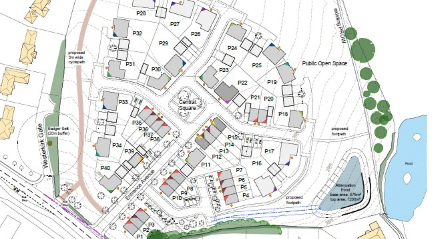
The layout has responded to all of the assessments of the site that have helped define the developable area, whilst complimenting important constraints, such as maintaining the Green Wedge objectives. In addition, the layout has had regard to the Taunton Garden Town - Design Checklist, incorporating features such as a tree lined street from the site access, culminating in a central green. This enables parcels of houses to face out onto the open space areas around the site. A note on the Compliance with the Taunton Garden Town Design Checklist has been prepared to provide more detail on the layout.
As currently proposed, the layout demonstrates how 40 dwellings can be accommodated at the site, 25% of which would be for affordable housing. Some bungalows are proposed in the most sensitive parts of the site. These are at plots 16 and 17, which is an area of the site with more open views of neighbouring properties and plots 26 to 28 that face the listed Kibby’s House.
The housing mix provides a range of 2, 3, 4 and 5 bedroom properties, with a range of sizes for each type of property. Aside from the previously mentioned 5 bungalows, the majority of the remaining properties would be of two storey construction, however three 2.5 story properties would frame the central green.
An attenuation pond is proposed in the south east corner of the site. Full ground investigation assessments have been undertaken to design the drainage strategy in accordance with Local Lead Flood Authority (LLFA) requirements.
Planning Policy Considerations
The site is clearly in a highly sustainable location and provides the following significant and substantial benefits:
- Housing and affordable housing
- Public Open Space beyond the amount required to make the development acceptable in planning terms
- Improved Active Travel connectivity
- Construction and supply chain jobs
- Resident expenditure benefits that is new to the area
- Local Authority revenue benefits in the form of council tax, new homes bonus payments and CIL receipts
- 10% Biodiversity net-gain
Next Steps
Please take time to review the detailed proposals in the download section and provide any comments using the following email address: planning.exeter@carneysweeney.co.uk by midnight on Sunday 20th September.
Any personal information provided as part of this consultation will be managed in accordance with our privacy policy.