April 2026 – Update
An outline planning application with all matters reserved except for access was validated by Cornwall Council on 16th April 2026. The application consists of the residential development of up to 75 dwellings and associated works.
If you wish to make formal comments on the planning application to be reviewed by the case officer, you are encouraged to provide these comments direct to Cornwall Council via the ‘Planning Application’ website or in writing to Cornwall Council Planning Dept, New County Hall, Treyew Rd, Truro, TR1 3AY quoting the application reference number PA26/02133.
If you wish to make further observations or recommendations to the applicant team, the consultation inbox remains open and will be monitored throughout the application period. Comments can be sent via email to planning.exeter@carneysweeney.co.uk or by post to CarneySweeney, Clockwise, Broadwalk House, Southernhay West, Exeter, EX1 1TS
The applicant team presented the development proposals at the meeting of St Agnes Parish Council’s Planning Committee on 20th April 2026. A copy of the presentation is available to view on the ‘File Downloads’ section of this web page. St Agnes Parish Council will be providing formal comments on the application at its next meeting of the Planning Committee scheduled for 18th May 2026.
CarneySweeney is carrying out an online public consultation on behalf of Obsidian Strategic to seek the views of the community on the proposals to deliver up to 75 new homes at Penwinnick Road, St Agnes. In addition to open market and affordable housing, the development will include areas of public open space, enhance pedestrian and cycle links to village amenities and deliver ecological enhancements on-site that provide an improved ecological habitat over and above the existing level.
This consultation describes the proposed development, its background and planning policy context.
Your feedback is important and we would be grateful if all comments are emailed to planning.exeter@carneysweeney.co.uk or posted to us at:
CarneySweeney Planning, Clockwise, Broadwalk House, Southernhay West, Exeter, EX1 1TS.
All comments raised from this consultation as well as from pre-application engagement with other stakeholders will be considered in advance of the planning application being made. A report of all comments received and the response of the applicant will be provided in a Statement of Community Involvement that is to be submitted with the planning application.
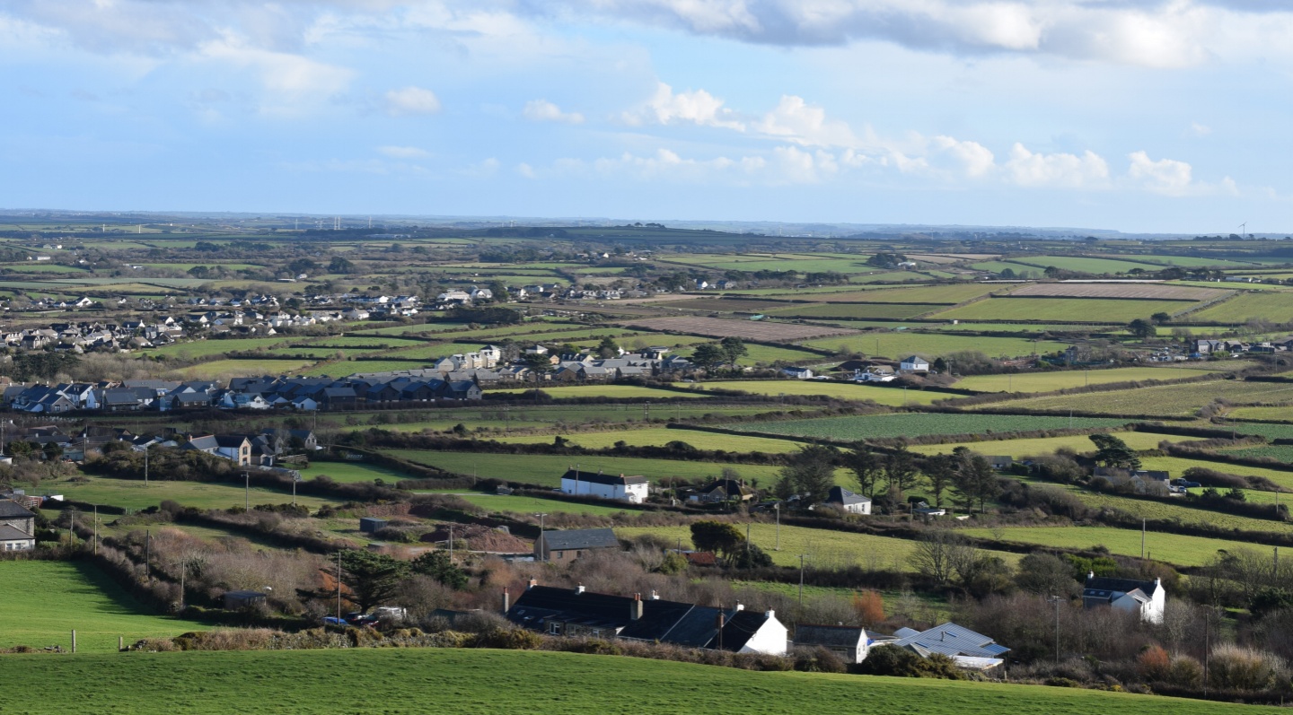
The site is situated to the south of St Agnes, along Penwinnick Road, sitting to the immediate south of recently constructed dwellings at Fordh Kober and west of the Park Kres residential area.

The development is proposed to deliver up to 75 new homes, 30% of which are to be delivered as affordable housing in accordance with Cornwall Council policy. The application responds to Cornwall Council’s interim policy position statement, published in 2025, which confirms the intention to ensure that homes are delivered in the right places, and at an appropriate scale to help meet Cornwall’s needs. The Council is to give significant weight to the delivery of housing at all scales to deliver a step change in housing with settlements that present a range of services and facilities considered the most sustainable locations to focus growth.
Given the Council’s recognition that a larger number of settlements will need to accommodate housing growth, in locational terms, and access to facilities and amenities, the site represents an opportunity to deliver the type of sustainable development envisaged.
In accordance with policy adopted as part of the St Agnes Neighbourhood Development Plan, all the properties will be subject to a planning condition restricting their use to principal residences only.
A link to the proposed Development Framework Plan is provided at the top of this page under ‘File Downloads’.

The concept behind the proposal has been developed from an extensive period of technical research and information gathering to ensure that a development enriches local character and enhances the village of St Agnes in a gateway location. To date, consideration has been given to landscape and long-distance views, heritage, ecology, trees, flood risk and drainage, transport, and architectural character.
Landscape
The site is visually well related to the existing village edge in long distance views from the St Agnes Beacon and the Saints Trail.
To ensure the development is landscape led, views towards the Beacon will be retained and emphasised and the existing field pattern is to be retained.
Heritage
A Historic Environment Desk Based Assessment has been prepared that addresses the potential setting impacts that the proposed development would have on the World Heritage Site, nearby Scheduled Monuments and Listed Buildings.
The assessment found that the proposed development would not affect the nearby Bolster Bank and have a negligible level of harm on the setting of the St Agnes Beacon and the Grade II Listed building of Penwinnick Farm. With sympathetic mitigation and screening, including establishing a design concept that is rooted with the character of St Agnes, the development is considered to have a low level of harm on the setting of the World Heritage Site.
Ecology
The development will deliver a 10% biodiversity enhancement over the existing condition of the site. This will be achieved through the creation of new habitats including trees and sustainable drainage features. Existing Cornish hedges will be enhanced by filling gaps with native woody species and any breaches of hedgerow required to facilitate access will be kept to a minimum.
The potential for foraging bats on the site is low, however, appropriate buffers have been designed into the development and a sensitive lighting strategy will be secured to ensure that potential bat foraging corridors are kept below 0.5 lux.
Drainage
The site lies within Flood Zone 1 and is at very low risk of surface water flooding. The surface water management strategy prioritises on-plot soakaways, permeable paving and communal soakaways, with the residual balance of runoff to be served by an infiltration basin, designed with an allowance for climate change.
South West Water have confirmed sufficient capacity to support foul flows from the development within their existing network, with no reinforcement works required.
Access
Vehicular access will be taken from the southern field directly off Penwinnick Road. The proposals include a 1.8m footway heading north to a new pedestrian crossing that will provide a connection to existing foot and cycle facilities on Penwinnick Road.
A separate pedestrian access is proposed in the north of the site on to Penwinnick Road.
Data from a 7-day traffic speed survey has established the visibility splays required for the proposed junction in line with Manual for Streets guidance.
Consultation Documents
The following documents are available to download and view at the top of this page:
- Development Framework Plan
- Local Character Analysis
- Concept and Approach
If you are unable to view the plans, please contact
planning.exeter@carneysweeney.co.uk